 ultimate-guide
Preventing Underground Utility Project Delays: A Guide
Quick Summary
Preventing underground utility project delays requires accurate utility records, early detection and potholing of conflict points, a single point of contact for each utility owner, and clear stop-work protocols. Most delays come from a single struck or undocumented line that halts an entire site. Treat utility work as a critical path item from the start.
- Request utility maps from owners during design, not after bids are awarded.
- Pothole high-risk crossings before excavation crews mobilize to confirm locations.
- Name one contact per utility owner with authority to stop work in an area.
- Stop work when an unexpected line is found and resume only after owner confirmation.
- Track expired locate tickets and days lost to utility stoppages at each progress meeting.
Table of Contents
- How Underground Utility Damage Causes Project Delays
- Common Causes of Utility Strikes and Construction Disruption
- Utility Mapping for Construction: Records, Detection and Field Verification
- 811 Utility Locating Before Excavation: Timelines and Responsibilities
- Building a Utility Coordination Plan Step by Step
- Underground Utility Project Scheduling, Risk Priorities and Delay KPIs
- Booking Your Next Step: Getting a Fixed-Price Utility Assessment
- Frequently Asked Questions
How Underground Utility Damage Causes Project Delays
Last Updated: November 5, 2026
Preventing underground utility project delays starts with understanding how a single damaged line can stop an entire site. For commercial development teams and municipal crews working in North Carolina, a struck gas, water, or sewer line rarely causes just a repair bill. It triggers stop-work orders, emergency callouts, inspections, and crew reassignments that ripple across the schedule for weeks.
Many project managers find that the hidden expense in preventing underground utility project delays is idle equipment and labor while the work area sits closed.
Damage to buried utilities generally disrupts projects in three ways:
- Immediate stoppage: Crews must clear the area, secure the site, and wait for the owner to respond.
- Re-sequencing: Excavation, grading, and paving work scheduled downstream has to be pushed back.
- Approval lag: Repairs often require coordination with utility owners and sometimes permit revisions before work can resume.
A common mistake is treating utility conflicts as isolated events. In practice, one undocumented line can shift foundation layouts, drainage plans, and inspection dates all at once.
Common Causes of Utility Strikes and Construction Disruption
Most utility strikes come from a small set of preventable causes. Incomplete or outdated utility records are the most frequent. When as-built drawings are missing or inaccurate, crews dig based on assumptions instead of verified locations.
Other common causes include:
- Excavating before a locate ticket is completed or refreshed
- Assuming a line is abandoned because it appears unused on a map
- Failing to account for private service laterals that do not appear on public records
- Changing grades or alignments during construction without updating utility data
What most guides miss is that disruption often begins before any digging starts. Design changes that move a storm drain or shift a water main alignment can invalidate earlier surveys. Re-verifying data after every significant design change is one of the cheapest delay-prevention steps available.
Utility Mapping for Construction: Records, Detection and Field Verification
Accurate utility mapping combines three sources: existing records, detection results, and field verification. Records alone are rarely enough, because municipal files can be decades old. Detection adds current signal data, and field verification confirms what is actually in the ground.
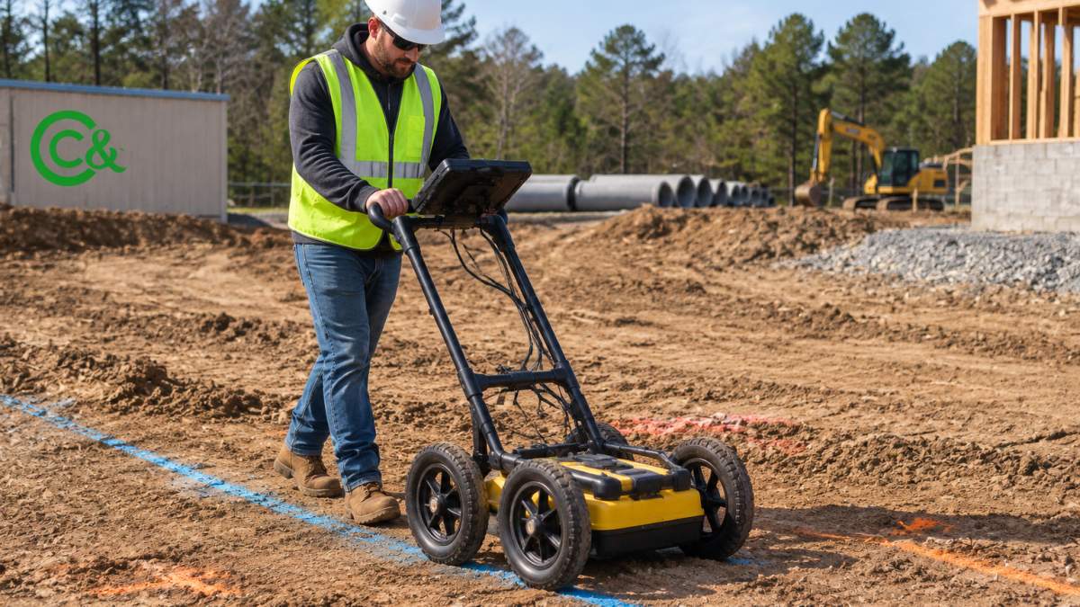
!A field crew member in a hard hat and high-visibility vest holding a ground-penetrating radar cart over marked utility paint lines on a graded construction site
Ground-Penetrating Radar and Other Detection Technologies
Ground-penetrating radar (GPR) sends radar pulses into the soil and reads the reflections from buried objects (Underground Utilities). It works well for many non-metallic lines, though soil moisture, clay, and dense debris can reduce its effectiveness. Electromagnetic locators are better suited to metallic pipes and tracer wire. Each technology has limits, so most projects use more than one method and treat the results as a starting point rather than a guarantee.
Federal Highway Administration guidance on subsurface utility engineering
Potholing and Field Verification Before Excavation
Potholing, the careful exposure of a utility with vacuum excavation or hand digging, is the step that turns an estimated location into a confirmed one. Many project teams schedule potholes at known crossing points before major excavation begins.
811 Utility Locating Before Excavation: Timelines and Responsibilities
Calling 811 before digging is the nationwide starting point for utility locating (811 Before You Dig). Once a ticket is filed, participating utility owners mark their lines, usually with paint and flags, within the timeframe set by state law. Excavators are responsible for respecting those marks and for keeping them visible throughout the work.
Responsibilities are divided. The excavator must submit the request, maintain a safe clearance zone around marked lines, and stop if a mark is missing or unclear. Utility owners are responsible for accurate, timely locates. Project managers should confirm ticket expiration dates, since a ticket that lapses mid-project forces a new locate and a new wait.
Building a Utility Coordination Plan Step by Step
A utility coordination plan assigns responsibility before problems appear. The following sequence works for most commercial and municipal sites, and each step should be tied to a named owner and a target date in the project schedule.
- Collect records early. Request all available utility maps from owners during design, not after bids are awarded. Build in time for utility owners to respond; a common pattern is that record requests take longer than expected because municipal files are stored in different departments.
- Identify conflict points. Mark where proposed work crosses or runs near existing lines. Rank each conflict by consequence, not just likelihood, so high-pressure gas mains and major transmission lines get attention first.
- Schedule detection and potholing. Verify high-risk crossings before excavation crews mobilize. Potholing at known crossing points turns an estimated location into a confirmed one and is often the cheapest step available for preventing underground utility project delays.
- Assign a single point of contact. Name one person to communicate with each utility owner, and give that person authority to stop work in an area when a line is found in an unexpected location.
- Set escalation paths. Define who makes the call when a line is found in an unexpected location, how quickly they must respond, and what documentation is required before work resumes. A clear stop-work, notification, documentation, redesign, and restart protocol prevents minor finds from becoming serious strikes.
- Update records after changes. Revise the utility plan whenever grades, alignments, or layouts change, and re-verify data after every significant design change.
A simple responsibility matrix helps keep the plan honest. Owners and designers are responsible for providing available records and approving design changes. Contractors are responsible for submitting locate requests, maintaining safe clearance zones, and stopping work when marks are missing or unclear. Utility owners are responsible for accurate, timely locates and for confirming the status of lines found in unexpected locations.
Watch out: an unexpected utility discovered mid-project should stop work in that area until the owner has confirmed the line's location and status. Resuming without confirmation is how minor finds become serious strikes.
Underground Utility Project Scheduling, Risk Priorities and Delay KPIs
Scheduling should treat utility work as a critical path item, not a preliminary task. Build buffer time around known conflict points and avoid stacking excavation in the same corridor as multiple utility relocations.
Prioritize risk by consequence, not just likelihood. A low-probability encounter with a high-pressure gas main deserves more attention than a frequent encounter with a small private lateral.
Document confidence in utility locations as part of the plan. A line shown only on an old as-built drawing is a different risk than a line confirmed by potholing, and the schedule should reflect that difference.
Track a small set of measurable indicators at each progress meeting:
- Number of locate tickets expired before work was completed
- Days between a utility discovery and confirmed owner response
- Percentage of crossings verified by potholing before excavation
- Schedule days lost to utility-related stoppages
- Utility-related change orders and their schedule impact
- Strike frequency by area and by utility type
Teams that review these numbers at each progress meeting can catch patterns early, such as a recurring conflict in one area or a utility owner with consistently slow response times.
The article lists the measurable indicators teams can track at each progress meeting to spot delay patterns early.
| Indicator | What it tracks | Why it matters |
|---|---|---|
| Expired locate tickets | Tickets lapsed before work finished | Forces a new locate and wait |
| Discovery-to-response days | Time from utility find to owner reply | Shows owner responsiveness |
| Potholed crossings | Share of crossings verified before digging | Confirms locations before excavation |
| Schedule days lost | Days lost to utility stoppages | Measures direct delay impact |
| Utility change orders | Change orders and their schedule impact | Reveals design-driven delays |
| Strike frequency | Strikes by area and utility type | Highlights recurring conflict zones |
Booking Your Next Step: Getting a Fixed-Price Utility Assessment
If your project includes known or suspected underground utilities, the most useful next step is a utility assessment before excavation begins. C & C Environmental Services provides camera inspections and full diagnostics for water and sewer lines, along with E/One certified pump installs and repairs. For current pricing or a quote, visit the C & C Environmental Services website. Contact us today to discuss your site and schedule an assessment. Before excavation begins, confirming utility locations can help prevent avoidable delays, and knowing how to find underground water pipes is an important part of that preparation.
Frequently Asked Questions
How can you avoid delays in underground utility construction projects?
Start utility locating and records review before design is finalized, not after excavation has begun. Request 811 locates early, verify marked lines with potholing where the design is tight, and build a coordination plan that names an owner for each utility. Schedule locate requests and field verification as explicit tasks on the critical path so they are not treated as optional. Teams that front-load this work usually find conflicts while they are still cheap to redesign around.
Can you dig 4 inches without calling 811?
No. Calling 811 before digging is required in all states, regardless of how shallow the excavation is. Even a few inches of digging can damage a buried gas line, fiber cable or water main, and the person doing the digging is responsible for the repair cost and any service outage. A locate request is free for the excavator and gives utility owners time to mark their lines. Planning for the locate in your schedule prevents the common delay of waiting for marks after crews are already on site.
How early should utility locating begin before excavation?
Begin with records research during design, then request 811 locates well before the excavation date. Most utility owners need several business days to mark their facilities, and complex sites with many owners can take longer. Build the locate lead time into your project schedule as a dependency, and re-request marks if the work sits idle past the marking validity period. Early locating also gives the design team time to adjust alignments before crews are mobilized.
What should a project team do when an unexpected utility is found?
Stop work in the immediate area, keep the exposed line protected, and notify the utility owner and the project engineer at once. Document the location with photos and measurements, and compare it against the records and markings. Update the utility map, reassess the design or excavation method, and agree on a relocation or protection plan with the owner before work resumes. Recording the find in a change log protects the schedule and the contract position.
What should a utility coordination plan include?
A useful coordination plan lists every known utility owner, the contact person, the locate and relocation timelines, and who approves changes. It also defines escalation paths for conflicts, the process for field verification, and the schedule milestones that depend on utility work. Include the plan's update cadence, typically weekly during active excavation, so everyone works from the same current information. Assigning a single coordinator to maintain the plan reduces confusion among owners, contractors and designers.
How can utility mapping help prevent construction delays?
Accurate utility mapping shows where facilities are likely to conflict with foundations, drainage and utility trenches before work begins. Combining records, locate results and ground-penetrating radar produces a more reliable picture than any single source. Mapped conflicts can be solved in design, which costs far less than solving them with a stopped excavator on site. Keep the map updated with field-verified data so it reflects what crews actually find.
How do weather and permitting affect underground utility schedules?
Rain can saturate soils, close trenches and delay locate markings that wash out, so build contingency days into wet-season schedules. Permits for road cuts or work in public right-of-way often have their own review periods, and a late permit can idle a crew for weeks. Apply for permits as soon as the utility scope is known, and track the permit status as a schedule item. Confirm with local public works offices how long each permit type takes before setting milestones.